| |

|
 |
|
Latitude: 42.77029754730348, Longitude: -70.84392070770264 | Click to get directions to Burying Ground of the First Settlers 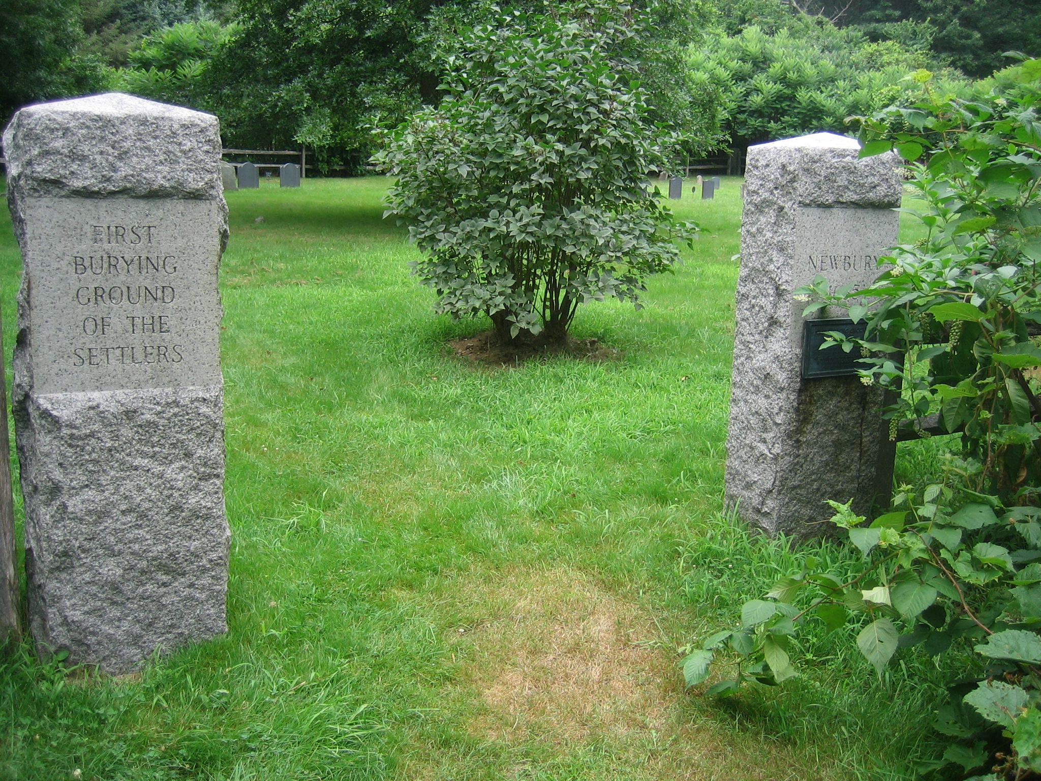
Notes:
Located at 238 High Road, Newbury
Nestled among the trees, a short distance from the traffic of High Road (Route 1A) is The Burying Ground of the First Settlers. Park along the main road at the sign and follow the path to the site.
History
On May 18, 1638 the town, for £3, granted to John Emery, “that parcel of land called the Greene.” “About 3 akers more or less, bounded by the half aker lotts on the west, the hyeway on the southeast, and his own land on the North, being in the triangle, only the 20 rodds is reserved in said land for a burying place, as it is, bounded by stakes with a way to the East.”
John Emery had been given the right to build at the end of the Green, that is, the field where the Jackman-Willett House now stands. In 1679 he conveyed his homestead and one-half the land granted him by the town to his son and moved farther north.
Jonathan Emery, in 1729, sold William and Richard Dole seventeen and one-half acres “Excepting and reserving the 20 Rods reserved for a burying place.” William Dole conveyed one-half of his estate to Joseph Ilsley in 1793 and Joseph Ilsley’s heirs conveyed to Paul Ilsley a part of their right, title and interest in the property. The land surrounding the burying place, now owned by the heirs of Mrs. Joseph Ilsley, is still known as the “Emery Field.”
This burying place was, therefore, some distance in the rear of the meeting-house and there some of the first settlers were buried. As families moved toward the Merrimack River the meeting-house was moved also. Although there was much remonstrance, and petitions against removal were sent to the General Court, all finally acquiesced in the removal of the meeting-house “to a knowle of upland by Abraham Toppans’s barne” in 1647. Here was begun a new burying ground now called the First Parish Burying Ground.
The last person buried in the first burying ground was Judith Ilsley, 1794. Gravestones became worn and dilapidated. Some graves were never marked and bodies were laid to some extent outside and beyond the “20 rodds” set off. Centuries of neglect and forgetfulness followed. Stones gradually disappeared, few remembered the spot, fewer cared and two brief attempts to restore the burying ground came to naught.
In 1927 the society of the Sons and Daughters of the First Settlers was organized. Among the earliest members were Mr. and Mrs. William I. Moore of New York. Mrs. Moore’s ancestor, Richard Dole and his wife, Hannah Rolfe, were buried in the first burying ground with stones still visible. Mrs. Moore, with her husband, offered to restore the place if it could be done under the auspices of the society.
Permission was obtained of the selectmen, Stuart Little, chairman, for the society to assume care of the place, with Mrs. Moore, trustee, appointed by the town.
Anne Colman Moody, 1935.
Founder and first President of the Sons & Daughters of the First Settlers of Newbury
In most recent years the cemetery was restored to its present pristine condition through the efforts of octogenarian and Newbury historian Richard Cunningham who cleard the brush and maintained the cemetery into his 90's.
Headstones
| Thumb | Description | Status | Location | Name (Died/Buried) |

|
Abraham Toppan memorial gravestone
|
Located |
1. Latitude: 42.77029754730348, Longitude: -70.84392070770264 |
TOPPAN Abraham, Sr. (d. 5 Nov 1672)
|
 Thurston memorial gravestone")
|
Anne (Pell) Thurston memorial gravestone
|
Located |
2. Latitude: 42.77029754730348, Longitude: -70.84392070770264 |
PELL Anna (d. Yes, date unknown)
|

|
Anthony Morse memorial gravestone
|
Located |
|
MORSE Anthony, Sr. (d. 12 Oct 1686)
|

|
Anthony Somerby memorial gravestone
|
Located |
|
SOMERBY Anthony (d. 31 Jul 1686)
|

|
Capt. Edmund Greenleaf memorial gravestone
|
Located |
3. Latitude: 42.77029754730348, Longitude: -70.84392070770264 |
Capt. GREENLEAF Edmund (d. 24 Mar 1670/1)
|
 Thurston children memorial gravestone")
|
Daniel & Anne (Pell) Thurston children memorial gravestone
Hannah Pearson Thurston
Daniel Thurston, Jr.
Joseph Thurston
James Thurston
Stephen Thurston
Abigail Chase Thurston |
Located |
|
THURSTON Abigail Chase (d. Yes, date unknown)
Sergt. THURSTON Daniel, Jr. (d. 16 Feb 1737)
THURSTON Hannah Pearson (d. 26 Jun 1731)
THURSTON James (d. Yes, date unknown)
THURSTON Joseph (d. Yes, date unknown)
THURSTON Stephen (d. Yes, date unknown)
|

|
Daniel Thurston memorial gravestone
|
Located |
|
THURSTON Danel, Sr. (d. 19 Feb 1693)
|
 Dole memorial gravestone")
|
Hannah (Rolfe) Dole memorial gravestone
|
Located |
|
ROLFE Hannah (d. 16 Nov 1678)
|
 Ordway memorial gravestone")
|
James & Anne (Emery) Ordway memorial gravestone
James is probably actually buried in First Parish Burial Ground near his wife Anne. |
Located |
|
EMERY Anne (d. 31 Mar 1687)
ORDWAY James (d. Aft 1711)
|

|
John Emery, Sr. memorial gravestone
|
Located |
|
EMERY John, Sr. (d. 3 Nov 1683)
|

|
Jonathan Plumer gravestone
|
Located |
|
PLUMER Jonathan (d. 26 Sep 1726)
|

|
Nathaniel Merrill memorial gravestone
|
Located |
|
MERRILL Nathaniel (d. 16 Mar 1655)
|

|
Richard Bartlett memorial gravestone
|
Located |
|
BARTLET Richard, Sr. (d. 25 May 1647)
|

|
Richard Dole, Jr. gravestone
|
Located |
4. Latitude: 42.77029754730348, Longitude: -70.84392070770264 |
DOLE Richard, Jr. (d. 1 Aug 1723)
|
 Dole gravestone")
|
Sarah (Greenleaf) Dole gravestone
|
Located |
5. Latitude: 42.77029754730348, Longitude: -70.84392070770264 |
GREENLEAF Sarah (d. Sep 1718)
|
 Swett memorial gravestone")
|
Stephen & Hannah (Merrill) Swett memorial gravestone
|
Located |
|
MERRILL Hannah (d. 4 Apr 1662)
SWETT Stephen (d. Yes, date unknown)
|

|
William Sawyer memorial gravestone
probably actually buried on his farm, now Sawyer's Hill Cemetery. |
Located |
|
SAWYER William, Sr. (d. 1702/3)
|
|
|
|